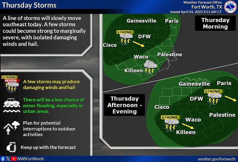

Two lines of storms will converge over North Texas on Thursday morning from 8 a.m. to 1 p.m. There is an isolated severity for strong wind, but the bigger concern is flash flooding.
Storms that formed in the Panhandle on Wednesday night formed into a line of storms that were just east of Wichita Falls and Abilene early Thursday. These storms have had a history of producing strong winds and a few brief spin-up Tornado Warnings. Heavy rain and a lot of noise are the threats. Many areas will see 1-2 inches of rain, with isolated higher totals possible. Temperatures will hover in the 70s all day long.
Another area of storms may encroach on the area Friday morning. Morning lows will dip into the mid-60s.
If the storms in West Texas hold together overnight, they will arrive Friday morning in a non-severe state. Most of Friday looks pretty decent with highs near 80 degrees with some sunshine.
A cold front will stall north of the area on Saturday, producing more showers and storms throughout the day. Interstate 20 is a good line to draw that will divide rain to the north and no rain to the south. This front will lift back to the north on Sunday, giving us a partly cloudy afternoon with highs warming into the middle 80s.
Monday and Tuesday will be nice and warm. Afternoon highs will reach the low to mid-80s each day with morning clouds and afternoon sun. It'll also be very humid and breezy.
Our next weather system arrives late Tuesday and may last at least through Thursday, with more scattered storms possible; some of these may become severe.
7-Day Headlines
DFW hit 81 degrees yesterday. 0.34” of rain on Wednesday.
Scattered showers and storms are expected through Saturday. Some severe.
Threats: Hail, wind, isolated tornadoes, isolated flooding. Welcome rain!
Drying out Sunday and Monday. Humidity!
Getting active again late Tuesday and Wednesday of next week.
*Wednesday Rain: 0.34”; Wednesday High: 81 Low: 63
*Thursday's Averages: High: 78; Low: 57
*Record high: 91 (1950, 1984, 2020): Record low: 37 (2013)
*April Rain: 1.93”; Deficit:
*2025 Rain: 10.64”; Deficit:
*Sunrise: 6:47am; Sunset: 8:06pm
Thursday: Cloudy and wet. Scattered showers and isolated severe storms. Threats: Hail, wind, and isolated flood. High: Mid 70s. Wind: South 10-20 mph.
Thursday night: Mostly cloudy and humid. Isolated showers and storms before daybreak. Threats: Hail and wind. Low: Mid to upper 60s. South 5-10 mph.
Friday: Mostly to partly cloudy and humid. Scattered showers and storms are expected by late evening. Isolated severe. High: Low 80s.
Saturday: Mostly cloudy and humid. Scattered strong storms. High: Near 80.
Sunday: Morning clouds, afternoon sun. High: Mid 80s.
Monday: Morning clouds and warm. High: Mid 80s.
Tuesday: Morning clouds, afternoon sun. Scattered strong storms late. High: Mid 80s.
Wednesday: Scattered showers and strong storms. High: Near 80.
LISTEN on the Audacy App
Tell your Smart Speaker to "PLAY 1080 KRLD"
Sign Up to receive our KRLD Insider Newsletter for more news
Follow us on Facebook | Twitter | Instagram | YouTube